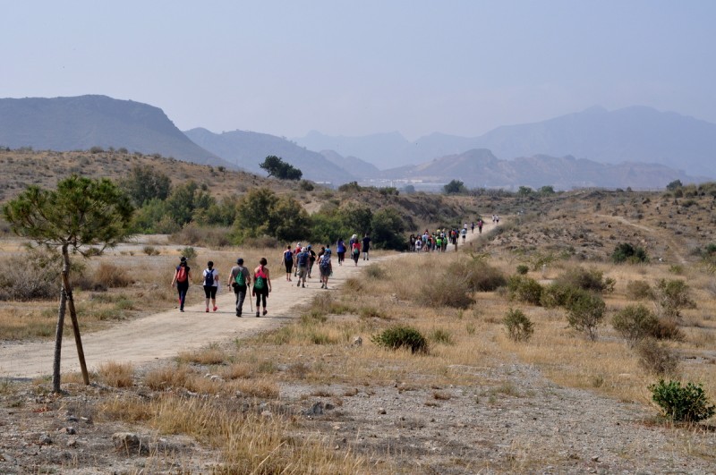
Via Verde – A Special Treat for cyclists and Walkers.
Hiking and Cycling around Los Altos From the coast to inland – Enjoy the scenery of the old railway line that was never actually built.
The Campo de Cartagena Via Verde has been recently developed for hiking and cycling comprises the 53.2 kilometers of the unfinished Cartagena – Totana railway, which crosses the Campo de Cartagena and the Guadalentín plain, linking the coast with the Sierra Espuña area. Halfway through, it links in La Pinilla close to Los Altos de Las Palas, and then connects with the Vía Verde de Mazarrón.
SITUATION :
Between Totana and Los Dolores (Cartagena)
CONNECTIONS :
Murcia: 42 km to Totana Murcia: 48 km to Cartagena
HOW TO GET THERE:
Simply drive the 6 minutes from Los Altos de Las Palas to Las Palas town centre and turn left on the main street towards La Pinilla, a total of around 12 minutes.
Section Cartagena – Fuente Álamo
The Vía Verde del Campo de Cartagena begins (or ends) in the neighborhood of Los Dolores (north of Cartagena) in a reception area next to the crossing of the old national highway 301-A, and goes west, through neighborhoods and peri-urban orchards, crossing under the AP-7 motorway.
Then begins a long straight line over the fruit and vegetable plain of Campo de Cartagena. Before the RM-E18 road junction and close to the Mancomunidad de Canales del Taibilla deposit (km 3.9), there is a rest area. About 7.9 km from the beginning, the town of La Aljorra is reached , and, skirting it, the road continues to the Casa Grande farm(km 10.8), where a large industry occupied the original layout many years ago, for which reason the passage through its perimeter has been enabled, implanting a small rest area at one vertex (km 16.0).
After finishing skirting the farm, the trace is recovered at the foot of the Sierra de Las Victorias, and, crossing a wild area and several ravines, it continues to Fuente Álamo , a town located about 20.8 km from the start and equipped with various services.
Fuente Álamo – La Pinilla section
Once the Fuente Álamo crossing is over, a long straight line begins again between citrus trees, almond trees and cattle farms. After passing through the small village of Campillo de Arriba (km 27.8), you reach the vicinity of the hamlet of La Pinilla (km 31.8), where the route forks in two: towards the northwest the road continues until Totana; and towards the west the “Vía Verde de Mazarrón” begins, which reaches the city of Mazarrón after a journey of 13.7 km.
La Pinilla – Totana section
Once the Fuente Álamo crossing is over, a long straight line begins again between citrus trees, almond trees and cattle farms. After passing through the small town of Campillo de Arriba (km 27.8), you reach the vicinity of the hamlet of La Pinilla (km 31.8), where the route forks in two: towards the northwest the road continues until Totana; and towards the west the “Vía Verde de Mazarrón” begins, which reaches the city of Mazarrón after a journey of 13.7 km. La Pinilla – Totana section On the way to Totana, the junction with the RM-E11 highway (km 36.2) is reached through an arid and undulating landscape, where a reception area has been set up and, in addition, continuity has been given to the overpass through a large metal walkway for pedestrians and cyclists.
Further on, near the Condado de Alhama resort, the track diverts to cross the RM-23 motorway through an underpass (km 40.1), and, once the railway line has been recovered, it heads to the solitary station of El Romeral (km 41.4), a strikingly sized building that never served a railway that was not.
In this area, the road borders the protected natural space of the Saladares del Guadalentín, an important crypto-wetland and steppe area. At km 46.2 is the bridge over the Guadalentín , the main railway masonry. From there, and in its long straightness through the agricultural plain of the Guadalentín river, the greenway becomes a paved track (“camino de la vía”) shared with vehicles.
Finally, after passing the Murcia-Lorca railway line along the upper road, the greenway ends (or begins) at the Totana railway station, an important town located at the foot of the Sierra Espuña natural park